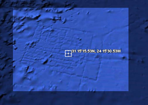
From what it sounds like, a British aeronautical engineer was playing around with the new Google Earth 5.0, which includes undersea data, and noticed something funny off the coast of Africa, about 600 miles west of the Canary Islands, that resembled a pattern of a street grid. According to the United Kingdom's Press Association, the pattern of streets equated to an area the size of Wales. In case you've had more important things to read about for the past few thousand years, Atlantis was a legendary island city first mentioned by Plato, allegedly a hard-core naval power located somewhere near North Africa that disappeared when it sank into the ocean. Guess global warming was a problem back then, too.
Anyway, most people think that Plato made it up, kind of like how those guys in Georgia made up the story about shooting Bigfoot, but others just won't stop believin'. So this guy is trawling the ocean floor with Google Earth--ah, if only we had that kind of free time on our hands--and was quick to announce his discovery. It looks like The Telegraph reported the story first, adding that the exact coordinates are 31 15'15.53N, 24 15'30.53W.